
Related Images


Download:
| Tiny | 96x128 | View | Download |
| Small | 192x256 | View | Download |
| Medium | 384x512 | View | Download |
| Original | 400x533 | View | Download |
This image was acquired from
wikimedia. It was marked as Public Domain or CC0 and is free to use. To verify, go to the source and check the information there.
Looking for more info about this image?
Try a Google Reverse Image Search for it.
Try a Google Reverse Image Search for it.
Keywords from Image Description:
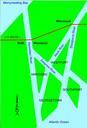
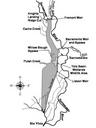
Yolo Bypass Schematic Map. en This is map of the Yolo Bypass that includes Fremont Weir Toe Drain Sacramento River and other important features of the bypass water ca gov Department of Water Resources other versions PDUSGov Yolo Bypass Wildlife Area