
Related Images


Download:
| Tiny | 179x128 | View | Download |
| Small | 358x256 | View | Download |
| Medium | 717x512 | View | Download |
| Original | 1315x938 | View | Download |
This image was acquired from
wikimedia. It was marked as Public Domain or CC0 and is free to use. To verify, go to the source and check the information there.
Looking for more info about this image?
Try a Google Reverse Image Search for it.
Try a Google Reverse Image Search for it.
Keywords from Image Description:
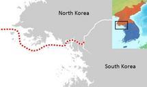
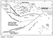
nm hypothetical Territorial Sea compared with Northern Limit Line North Korea. en US Government map showing where North Korean nautical mile Territorial Waters limit would be when disregarding the north west UN Command islands compared to the UN Command created Northern Limit Line US Government date Map taken from HTML version