
Related Images


Download:
| Tiny | 155x128 | View | Download |
| Small | 311x256 | View | Download |
| Medium | 622x512 | View | Download |
| Large | 1245x1024 | View | Download |
| Original | 6000x4933 | View | Download |
This image was acquired from
wikimedia. It was marked as Public Domain or CC0 and is free to use. To verify, go to the source and check the information there.
Looking for more info about this image?
Try a Google Reverse Image Search for it.
Try a Google Reverse Image Search for it.
Keywords from Image Description:
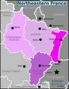
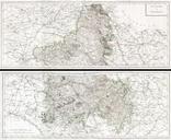
Tardieu Map of Champagne France Geographicus Champagnetardieu. This is rare and enormous Tardieu map of the Champagne region of France br Printed during the French Revolution an de la Republique Covers from Paris in the west to SarreLouis in the east from Rocroi in the north to Avallon in the south Includes the full extent