
Related Images


Download:
| Tiny | 176x128 | View | Download |
| Small | 353x256 | View | Download |
| Medium | 707x512 | View | Download |
| Original | 993x719 | View | Download |
This image was acquired from
wikimedia. It was marked as Public Domain or CC0 and is free to use. To verify, go to the source and check the information there.
Looking for more info about this image?
Try a Google Reverse Image Search for it.
Try a Google Reverse Image Search for it.
Keywords from Image Description:
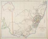
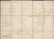
NSWMitchell. The south eastern portion of Australia showing the routes of the three expeditions and the surveyed territory Mitchell's map of Victoria and New South Wales showing towns major rivers and the limits of the Colony at the time The map shows in red the routes taken by Mitchell's expedition and camps Major Thomas Mitchell's