Related Images


Download:
| Tiny | 177x128 | View | Download |
| Small | 355x256 | View | Download |
| Medium | 710x512 | View | Download |
| Large | 1421x1024 | View | Download |
| Original | 9584x6906 | View | Download |
This image was acquired from
wikimedia. It was marked as Public Domain or CC0 and is free to use. To verify, go to the source and check the information there.
Looking for more info about this image?
Try a Google Reverse Image Search for it.
Try a Google Reverse Image Search for it.
Keywords from Image Description:
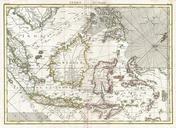
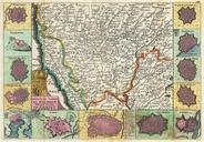
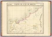
A map of Northwestern Borneo drawn by Vandermaelen Philippe. en map published in Brussels France in depicting the Northwestern Borneo which includes Sarawak part of Sabah and part of West Kalimantan Among the place names shown in the map are Tanjong Datou present day Tanjung Datu Sarawak Calca present day Kalaka Sarawak Baram present