
Related Images


Download:
| Tiny | 156x128 | View | Download |
| Small | 312x256 | View | Download |
| Medium | 624x512 | View | Download |
| Large | 1249x1024 | View | Download |
| Original png | 3500x2868 | View | Download |
| Original as jpg | 3500x2868 | View | Download |
This image was acquired from
wikimedia. It was marked as Public Domain or CC0 and is free to use. To verify, go to the source and check the information there.
Looking for more info about this image?
Try a Google Reverse Image Search for it.
Try a Google Reverse Image Search for it.
Keywords from Image Description:
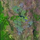
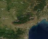
Annotated Satellite Picture of Montagne Noire. Outline of the Montagne Noire Geographic extent in red geologic extent in cyan Departements in grey Umriss der Montagne Noire Geographische Ausdehnung in rot geologische Ausdehnung in cyan Departementgrenzen in grau La Montagne Noire en photo satllite tendue gographique en rouge tendue