
Related Images


Download:
| Tiny | 201x128 | View | Download |
| Small | 402x256 | View | Download |
| Medium | 805x512 | View | Download |
| Original | 1276x811 | View | Download |
This image was acquired from
wikimedia. It was marked as Public Domain or CC0 and is free to use. To verify, go to the source and check the information there.
Looking for more info about this image?
Try a Google Reverse Image Search for it.
Try a Google Reverse Image Search for it.
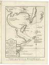
Keywords from Image Description:
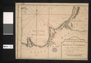
Conception Bay Bellin Nicolaus. en Plan of the 'Conception Bay' near port St Vincent On the map we find details like depths in the sea sand banks anchor places etc Detailed and interesting map engraved by Bellin after earlier voyages htm Creator JacquesNicolas Bellin PDold Concepcin Chile Maps by JacquesNicolas Bellin maps