
Related Images


Download:
| Tiny | 161x128 | View | Download |
| Small | 323x256 | View | Download |
| Original png | 525x415 | View | Download |
| Original as jpg | 525x415 | View | Download |
This image was acquired from
wikimedia. It was marked as Public Domain or CC0 and is free to use. To verify, go to the source and check the information there.
Looking for more info about this image?
Try a Google Reverse Image Search for it.
Try a Google Reverse Image Search for it.
Keywords from Image Description:
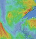
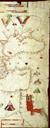
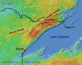
Duluthcomplexmap. geo umn edu Shadedrelief image of northeast Minnesota and adjoining areas in central North America meter grid Shuttle Radar Topography Mission SRTM of jpl nasa gov NASA Jet Propulsion Laboratory republished by University of Minnesota Department of Geology and Geophysics The crescentshaped region north of Lake