
Related Images


Download:
| Tiny | 266x128 | View | Download |
| Small | 533x256 | View | Download |
| Original svg | 876x420 | View | Download |
| Original as jpg | 876x420 | View | Download |
This image was acquired from
wikimedia. It was marked as Public Domain or CC0 and is free to use. To verify, go to the source and check the information there.
Looking for more info about this image?
Try a Google Reverse Image Search for it.
Try a Google Reverse Image Search for it.
Keywords from Image Description:
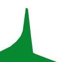
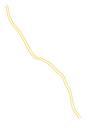
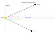
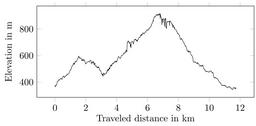
Elevationchart.svg de Hhenprofil des Genieerpfades Dieser startet und endet in Ottenhfen Er fhrt an dem EdelfrauengrabWasserfall vorbei und ber den Karlsruher Grat en Elevation chart of the hiking tour Genieerpfad starting and ending in Ottenhfen BadenWrttemberg Germany going over the Karlsruher Grat own MartinThoma other versions