
Related Images


Download:
| Tiny | 120x128 | View | Download |
| Small | 240x256 | View | Download |
| Original png | 271x288 | View | Download |
| Original as jpg | 271x288 | View | Download |
This image was acquired from
wikimedia. It was marked as Public Domain or CC0 and is free to use. To verify, go to the source and check the information there.
Looking for more info about this image?
Try a Google Reverse Image Search for it.
Try a Google Reverse Image Search for it.
Keywords from Image Description:
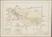
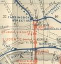
Extract of Railway Map Showing Ludgate Hill Holborn Viaduct stations. Extract of map taken from London and its Environs Handbook for Travellers by Baedeker PDold Old maps of London Rail transport maps of London Metropolitan Railway Metropolitan District Railway South Eastern and Chatham Railway Blackfriars station Holborn Viaduct