
Related Images


Download:
| Tiny | 223x128 | View | Download |
| Small | 446x256 | View | Download |
| Original png | 642x368 | View | Download |
| Original as jpg | 642x368 | View | Download |
This image was acquired from
wikimedia. It was marked as Public Domain or CC0 and is free to use. To verify, go to the source and check the information there.
Looking for more info about this image?
Try a Google Reverse Image Search for it.
Try a Google Reverse Image Search for it.
Keywords from Image Description:
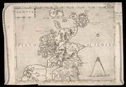
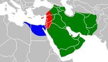
First Fitna map. Map of the th century First Islamic Civil War First Fitna territories Regions under the control of Muawiyah red 'Amr ibn al'As blue and Ali ibn Abi Talib green during the First Islamic Civil War First Fitna Based on this animated map Own Yenemus File FirstFitnamapblank svg First Fitna Maps of the Rashidun Caliphate