
Related Images


Download:
| Tiny | 158x128 | View | Download |
| Small | 317x256 | View | Download |
| Medium | 635x512 | View | Download |
| Large | 1270x1024 | View | Download |
| Original | 1708x1377 | View | Download |
This image was acquired from
wikimedia. It was marked as Public Domain or CC0 and is free to use. To verify, go to the source and check the information there.
Looking for more info about this image?
Try a Google Reverse Image Search for it.
Try a Google Reverse Image Search for it.
Keywords from Image Description:
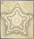
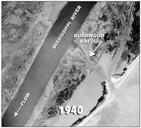
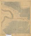
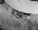
FortStPhilipAir. Fort St Philip Plaquemines Parish Louisiana Air view showing condition of the Fort at the time and the surrounding area with farmland bend in the Mississippi River Army Corps of Engineers photo extracted from PDF at focus nps gov pdf PDUSGov in Louisiana Fort St Philip Louisiana Aerial photographs of Louisiana