
Related Images


Download:
| Tiny | 181x128 | View | Download |
| Small | 363x256 | View | Download |
| Medium | 727x512 | View | Download |
| Large | 1454x1024 | View | Download |
| Original | 2400x1690 | View | Download |
This image was acquired from
wikimedia. It was marked as Public Domain or CC0 and is free to use. To verify, go to the source and check the information there.
Looking for more info about this image?
Try a Google Reverse Image Search for it.
Try a Google Reverse Image Search for it.
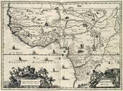
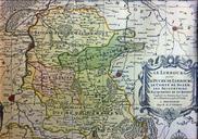
Keywords from Image Description:
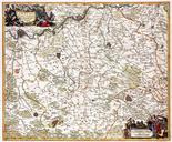
Kaart van Limburg en Landen van Overmaas Atlas Major en Ottens Amsterdam ca historische collectie Streekmuseum Het Land van Valkenburg Limburg. en thcentury map of the Meuse region around Maastricht Lige and Aachen with the duchy of Limburg the county of Dalhem and the lands of Valkenburg and Herzogenrath Rolduc Map published around