
Related Images


This image was acquired from
wikimedia. It was marked as Public Domain or CC0 and is free to use. To verify, go to the source and check the information there.
Looking for more info about this image?
Try a Google Reverse Image Search for it.
Try a Google Reverse Image Search for it.
Keywords from Image Description:
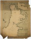
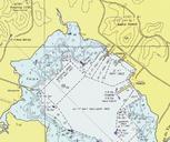
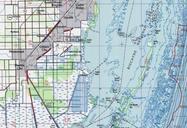
Lowerbiscaynebaychart. Downloaded from ncd noaa gov asp Historical Map Chart Project Image Catalog MIAMI FL TOPOGRAPHIC BATHYMETRIC MAP ATB portion PDUSGov original upload log page en Lowerbiscaynebaychart Dalbury bytes no from ncd noaa gov asp Historical Map Chart Project Image Catalog MIAMI FL TOPOGRAPHIC BATHYMETRIC