
Related Images


This image was acquired from
wikimedia. It was marked as Public Domain or CC0 and is free to use. To verify, go to the source and check the information there.
Looking for more info about this image?
Try a Google Reverse Image Search for it.
Try a Google Reverse Image Search for it.
Keywords from Image Description:
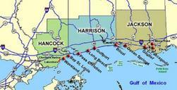
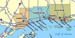
MississippiCoasttownsNOAA. Coastal map of the state of Mississippi showing major towns and cities in the three coastal counties Hancock Harrison and Jackson County Also shown are Cat Island West Ship Island East Ship Island Horn Island and Petit Bois Island The locations of towns roads and offshore islands are based on NOAA and NASA