
Related Images


Download:
| Tiny | 104x128 | View | Download |
| Small | 208x256 | View | Download |
| Medium | 417x512 | View | Download |
| Large | 834x1024 | View | Download |
| Original | 1951x2395 | View | Download |
This image was acquired from
wikimedia. It was marked as Public Domain or CC0 and is free to use. To verify, go to the source and check the information there.
Looking for more info about this image?
Try a Google Reverse Image Search for it.
Try a Google Reverse Image Search for it.
Keywords from Image Description:
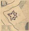
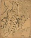
Plan of the country at and in the vicinity of Forts Lee and Independency . Plan of the country at and in the vicinity of Forts Lee and Independency showing the position of the British Army Scale ca Title from Philip Lee Phillips' list of maps of America Manuscript penandink and watercolor Has watermarks Shows British and Hessian