
Related Images


Download:
| Tiny | 224x128 | View | Download |
| Small | 449x256 | View | Download |
| Medium | 898x512 | View | Download |
| Large | 1796x1024 | View | Download |
| Original | 4074x2322 | View | Download |
This image was acquired from
wikimedia. It was marked as Public Domain or CC0 and is free to use. To verify, go to the source and check the information there.
Looking for more info about this image?
Try a Google Reverse Image Search for it.
Try a Google Reverse Image Search for it.
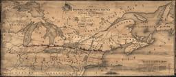
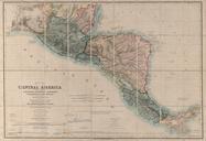
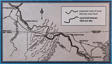
Keywords from Image Description:
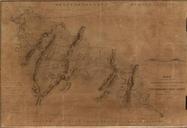
Proposed Map of and Canal. en Proposed Map of Chesapeake and Ohio Canal including portions never built The line follows Wills Creek north from Cumberland to Hyndman PA continues north up Little Wills Creek north and west It crosses the Eastern Divide follows Buffalo Creek just south of Berlin PA to Garret PA on the Casselman River