
Related Images

Download:
| Tiny | 125x128 | View | Download |
| Small | 251x256 | View | Download |
| Medium | 502x512 | View | Download |
| Large | 1005x1024 | View | Download |
| Original | 1843x1876 | View | Download |
This image was acquired from
wikimedia. It was marked as Public Domain or CC0 and is free to use. To verify, go to the source and check the information there.
Looking for more info about this image?
Try a Google Reverse Image Search for it.
Try a Google Reverse Image Search for it.
Keywords from Image Description:
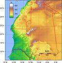
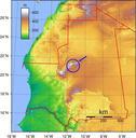
Richat Structure in Mauritania Topographic map. Topography of Mauritania Created with GMT from GLOBE data MauritaniaTopography UTC MauritaniaTopography Sadalmelik derivative work talk Location Richat Structure MauritaniaTopography Topographic maps of Mauritania Topographic Uploaded with derivativeFX Category Topographic maps