
Related Images


Download:
| Tiny | 91x128 | View | Download |
| Small | 183x256 | View | Download |
| Medium | 367x512 | View | Download |
| Original | 656x914 | View | Download |
This image was acquired from
wikimedia. It was marked as Public Domain or CC0 and is free to use. To verify, go to the source and check the information there.
Looking for more info about this image?
Try a Google Reverse Image Search for it.
Try a Google Reverse Image Search for it.
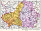
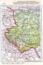
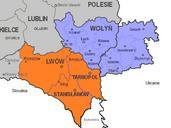
Keywords from Image Description:
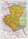
Soviet annexation of eastern Poland to Ukrainian SSR . Soviet map of expanded Ukrainian SSR year Territories captured during the Soviet invasion of the Second Polish Republic in marked in yellow renamed as Volynska Drogobych Lviv Rivne Stanislav Tarnopil and Chernivitsi Oblasts The adjacent parts of Poland occupied by Nazi Germany