
Related Images


Download:
| Tiny | 160x128 | View | Download |
| Small | 321x256 | View | Download |
| Medium | 642x512 | View | Download |
| Large | 1284x1024 | View | Download |
| Original | 9706x7739 | View | Download |
This image was acquired from
wikimedia. It was marked as Public Domain or CC0 and is free to use. To verify, go to the source and check the information there.
Looking for more info about this image?
Try a Google Reverse Image Search for it.
Try a Google Reverse Image Search for it.
Keywords from Image Description:
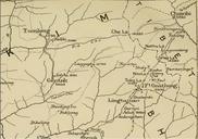
Thomas Hutchins Map of Henry Bouquet's Expedition. Uploaded with en wp UW marker en GENERAL MAP of the COUNTRY on the OHIO and MUSKINGHAM Shewing the Situation of the INDIAN TOWNS with respect to the ARMY under the Command of COLONEL BOUQUET by Tho's Hutchins Ass't Engineer Topographical PLAN of that part of the INDIAN COUNTRY