
Related Images
Download:
| Tiny | 188x128 | View | Download |
| Small | 377x256 | View | Download |
| Medium | 754x512 | View | Download |
| Large | 1509x1024 | View | Download |
| Original | 2500x1696 | View | Download |
This image was acquired from
wikimedia. It was marked as Public Domain or CC0 and is free to use. To verify, go to the source and check the information there.
Looking for more info about this image?
Try a Google Reverse Image Search for it.
Try a Google Reverse Image Search for it.
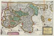
Keywords from Image Description:
La Feuille Map of Northern Holland Geographicus NoordHollandratelband. stunning map of the northern part of Holland or the Netherlands first drawn by Daniel de la Feuille in Oriented to the west Covers from Amsterdam at the far right northward as far as Texel and southward as far as Enkhuizen Features some offshore detail and