Related Images


Download:
| Tiny | 110x128 | View | Download |
| Small | 221x256 | View | Download |
| Medium | 443x512 | View | Download |
| Large | 886x1024 | View | Download |
| Original tiff | 4968x5739 | View | Download |
| Original as jpg | 4968x5739 | View | Download |
This image was acquired from
wikimedia. It was marked as Public Domain or CC0 and is free to use. To verify, go to the source and check the information there.
Looking for more info about this image?
Try a Google Reverse Image Search for it.
Try a Google Reverse Image Search for it.
Keywords from Image Description:
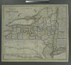
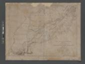
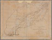
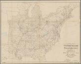
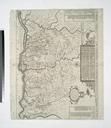
A map prepared for the report of the New York Erie R.R. Co. exhibiting the line of the N.Y. E. R. Road the present state of the work together with the area of the country tributary to NYPL. map hand col cm Maps of New York City and State Whole Stephen Schwarzman Building The Lionel Pincus and Princess Firyal Map Division