
Related Images


This image was acquired from
wikimedia. It was marked as Public Domain or CC0 and is free to use. To verify, go to the source and check the information there.
Looking for more info about this image?
Try a Google Reverse Image Search for it.
Try a Google Reverse Image Search for it.
Keywords from Image Description:
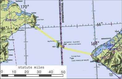
BeringBridge. map Possible routing of International Peace Bridge Source of basemap World Aeronautical Chart CC Federal Aviation Administration Cleaned up and annotatated by contributor PDUSGov Diomede Islands Bering Strait