
Related Images


Download:
| Tiny | 164x128 | View | Download |
| Small | 328x256 | View | Download |
| Medium | 657x512 | View | Download |
| Large | 1314x1024 | View | Download |
| Original | 1318x1027 | View | Download |
This image was acquired from
wikimedia. It was marked as Public Domain or CC0 and is free to use. To verify, go to the source and check the information there.
Looking for more info about this image?
Try a Google Reverse Image Search for it.
Try a Google Reverse Image Search for it.
Keywords from Image Description:
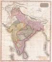
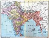
IndiaPoliticalConstablesHandAtlas. Map Political Map of the Indian Empire from Constable's Hand Atlas of India London Archibald Constable and Sons Uploaded by Fowler fowlerTalk February UTC google id kAuAAAAYAAJ John Bartholomew and Co Edinburgh old map PDold Maps of British India maps of India Old maps of the Indian Subcontinent