
Related Images


Download:
| Tiny | 226x128 | View | Download |
| Small | 453x256 | View | Download |
| Medium | 906x512 | View | Download |
| Original png | 972x549 | View | Download |
| Original as jpg | 972x549 | View | Download |
This image was acquired from
wikimedia. It was marked as Public Domain or CC0 and is free to use. To verify, go to the source and check the information there.
Looking for more info about this image?
Try a Google Reverse Image Search for it.
Try a Google Reverse Image Search for it.
Keywords from Image Description:
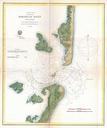
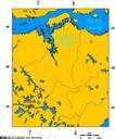
Kootznahoo Inlet map. en Kootznahoo Inlet map USGS Bulletin The Juneau Gold Belt Alaska Arthur Spencer other versions PDUSGov Old maps of Alaska Admiralty Island Alaska Geological maps of Alaska Chatham Strait The Juneau Gold Belt Alaska USGS Bulletin Bays of Alaska