
Related Images


Download:
| Tiny | 166x128 | View | Download |
| Small | 333x256 | View | Download |
| Medium | 667x512 | View | Download |
| Large | 1335x1024 | View | Download |
| Original svg | 1676x1285 | View | Download |
| Original as jpg | 1676x1285 | View | Download |
This image was acquired from
wikimedia. It was marked as Public Domain or CC0 and is free to use. To verify, go to the source and check the information there.
Looking for more info about this image?
Try a Google Reverse Image Search for it.
Try a Google Reverse Image Search for it.
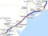
Keywords from Image Description:
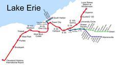
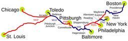
NEC map.svg Map of the Northeast Corridor traced on USGS topos Legend Red Amtrak ownership Blue NEC commuter services and NEC commuter rail agency ownership Black offNEC Amtrak lines not owned by Amtrak Green stations on the NEC Amtrak only User SPUI own USGS topographic maps spuimap Rail transport maps of the United States