
Related Images


Download:
| Tiny | 128x128 | View | Download |
| Small | 256x256 | View | Download |
| Medium | 512x512 | View | Download |
| Original svg | 720x720 | View | Download |
| Original as jpg | 720x720 | View | Download |
This image was acquired from
wikimedia. It was marked as Public Domain or CC0 and is free to use. To verify, go to the source and check the information there.
Looking for more info about this image?
Try a Google Reverse Image Search for it.
Try a Google Reverse Image Search for it.
Keywords from Image Description:
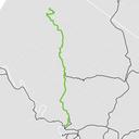
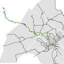
SchuylkillRiverTrailMap.svg en Map of the Schuylkill River Trail shown within the Delaware Valley Regional Planning Commission region Green signifies existing segments Magenta signifies segments in progress Teal signifies planned segments Data Municipalities counties and trails shapefiles as of from DVRPC dvrpc org htm Mapping