
Related Images


Download:
| Tiny | 192x128 | View | Download |
| Small | 384x256 | View | Download |
| Medium | 768x512 | View | Download |
| Large | 1536x1024 | View | Download |
| Original | 2250x1500 | View | Download |
This image was acquired from
wikimedia. It was marked as Public Domain or CC0 and is free to use. To verify, go to the source and check the information there.
Looking for more info about this image?
Try a Google Reverse Image Search for it.
Try a Google Reverse Image Search for it.
Keywords from Image Description:
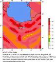
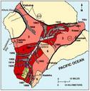
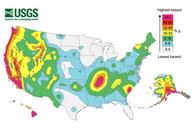
Seismic Hazard Map . National seismic hazards maps display earthquake ground motions for various probability levels across the United States These maps are the basis for seismic design provisions of building codes insurance rate structures and landuse planning See also nist gov cfm www nist gov cfm Credit Geological Survey Disclaimer