
Related Images


Download:
| Tiny | 154x128 | View | Download |
| Small | 308x256 | View | Download |
| Medium | 617x512 | View | Download |
| Large | 1234x1024 | View | Download |
| Original | 3500x2904 | View | Download |
This image was acquired from
wikimedia. It was marked as Public Domain or CC0 and is free to use. To verify, go to the source and check the information there.
Looking for more info about this image?
Try a Google Reverse Image Search for it.
Try a Google Reverse Image Search for it.
Keywords from Image Description:
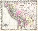
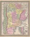
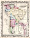
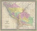
Mitchell Map of Peru and Bolivia Geographicus PeruBoliviamitchell. An attractive example of Mitchell Senior Map of Peru and Bolivia Covers from Equator south to La Plata When this map was made Bolivia had access to the sea through the province of Potosi this territory is not controlled by Chili Prepared by Mitchell for publication