
Related Images


Download:
| Tiny | 161x128 | View | Download |
| Small | 322x256 | View | Download |
| Medium | 644x512 | View | Download |
| Large | 1288x1024 | View | Download |
| Original | 3000x2385 | View | Download |
This image was acquired from
wikimedia. It was marked as Public Domain or CC0 and is free to use. To verify, go to the source and check the information there.
Looking for more info about this image?
Try a Google Reverse Image Search for it.
Try a Google Reverse Image Search for it.
Keywords from Image Description:
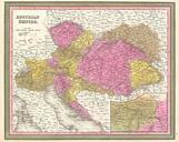
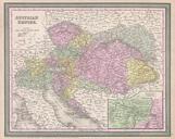
Mitchell Map of Austria Geographicus Austraimitchell. An attractive example of Mitchell Sr map of the Austrian Empire Includes much of today's Austria Hungary Romania Albania Serbia and Croatia Depicts the entire country color coded according to individual states Lower right quadrant features an inset map of the Environs of Vienna