
Related Images


Download:
| Tiny | 158x128 | View | Download |
| Small | 316x256 | View | Download |
| Medium | 632x512 | View | Download |
| Large | 1265x1024 | View | Download |
| Original | 3000x2427 | View | Download |
This image was acquired from
wikimedia. It was marked as Public Domain or CC0 and is free to use. To verify, go to the source and check the information there.
Looking for more info about this image?
Try a Google Reverse Image Search for it.
Try a Google Reverse Image Search for it.
Keywords from Image Description:
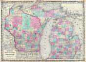
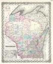
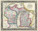
Mitchell Map of Michigan and Wisconsin first edition Geographicus MIWImitchell. beautiful example of the first edition of Mitchell map of Michigan and Wisconsin Depicts both states in considerable detail with color coding at the county level Also includes all of Lake Michigan and Lake Huron as well as parts of Lake Superior