
Related Images


Download:
| Tiny | 154x128 | View | Download |
| Small | 308x256 | View | Download |
| Medium | 617x512 | View | Download |
| Large | 1235x1024 | View | Download |
| Original | 3500x2902 | View | Download |
This image was acquired from
wikimedia. It was marked as Public Domain or CC0 and is free to use. To verify, go to the source and check the information there.
Looking for more info about this image?
Try a Google Reverse Image Search for it.
Try a Google Reverse Image Search for it.
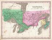
Keywords from Image Description:
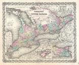
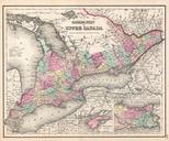
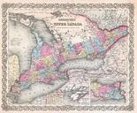
Colton Map of Upper Canada or Ontario Geographicus Ontariocolton. An excellent first edition example of Colton's rare map of Ontario Covers what at the time was called Upper or West Canada from Michigan to Montreal Includes Lake Erie Lake Ontario and part of Lake Huron Two insets in the lower right quadrant detail Wolf Island