
Related Images
Download:
| Tiny | 157x128 | View | Download |
| Small | 314x256 | View | Download |
| Medium | 628x512 | View | Download |
| Large | 1256x1024 | View | Download |
| Original | 4000x3261 | View | Download |
This image was acquired from
wikimedia. It was marked as Public Domain or CC0 and is free to use. To verify, go to the source and check the information there.
Looking for more info about this image?
Try a Google Reverse Image Search for it.
Try a Google Reverse Image Search for it.
Keywords from Image Description:
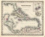
Colton Map of the West Indies Geographicus WestIndiescolton. beautiful first edition example of Colton's map of the West Indies Centered on Santo Domingo Hispaniola this map extends north to include the to cover all of Florida south as far as Panama Bay and northern South America and east as far as Barbados and the Windward Islands