
Related Images


Download:
| Tiny | 91x128 | View | Download |
| Small | 182x256 | View | Download |
| Medium | 365x512 | View | Download |
| Large | 731x1024 | View | Download |
| Original | 2859x4000 | View | Download |
This image was acquired from
wikimedia. It was marked as Public Domain or CC0 and is free to use. To verify, go to the source and check the information there.
Looking for more info about this image?
Try a Google Reverse Image Search for it.
Try a Google Reverse Image Search for it.
Keywords from Image Description:
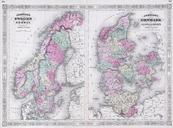
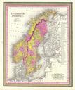
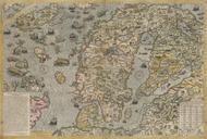
Johnson's Map of Scandinavia Norway Sweden Finland Denmark Geographicus Scandinaviajohnson. stunning example of the Johnson and Ward map of Scandinavia Includes Norway Sweden Denmark and Prussia Also includes most and in some cases all of Finland Poland Estonia Latvia Lithuania and parts of western Russia though they are not