
Related Images


Download:
| Tiny | 150x128 | View | Download |
| Small | 300x256 | View | Download |
| Medium | 601x512 | View | Download |
| Large | 1202x1024 | View | Download |
| Original | 3078x2621 | View | Download |
This image was acquired from
wikimedia. It was marked as Public Domain or CC0 and is free to use. To verify, go to the source and check the information there.
Looking for more info about this image?
Try a Google Reverse Image Search for it.
Try a Google Reverse Image Search for it.
Keywords from Image Description:
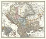
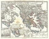
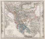
Perthes Map of Greece and the Balkans Geographicus Griechenlandperthes. This fascinating map by Justus Perthes and Stieler depicts Greece the Balkans parts of Turkey and the islands of the Adriatic as far south as Crete or Candia Extends as far north as Croatia Bosnia Serbia Bulgaria Rumania and Macedonia In cartographic flourish