
Related Images


Download:
| Tiny | 157x128 | View | Download |
| Small | 314x256 | View | Download |
| Medium | 628x512 | View | Download |
| Large | 1257x1024 | View | Download |
| Original | 4000x3258 | View | Download |
This image was acquired from
wikimedia. It was marked as Public Domain or CC0 and is free to use. To verify, go to the source and check the information there.
Looking for more info about this image?
Try a Google Reverse Image Search for it.
Try a Google Reverse Image Search for it.
Keywords from Image Description:
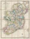
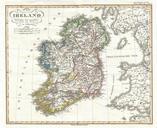
Perthes Map of Ireland Geographicus Irelandperthes. This is fine early example of Justus Perthes Map of Ireland Shows the island divided into four districts Ulster Connaught Leister and Munster Shows roads railroads local political divisions and some of the surrounding waters and territories in England and Scotland Drawn by von