
Related Images

Download:
| Tiny | 81x128 | View | Download |
| Small | 162x256 | View | Download |
| Medium | 324x512 | View | Download |
| Large | 648x1024 | View | Download |
| Original | 5000x7899 | View | Download |
This image was acquired from
wikimedia. It was marked as Public Domain or CC0 and is free to use. To verify, go to the source and check the information there.
Looking for more info about this image?
Try a Google Reverse Image Search for it.
Try a Google Reverse Image Search for it.
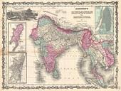
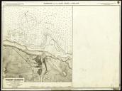
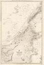
Keywords from Image Description:
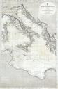
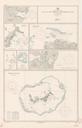
British Admiralty Chart or Map of Bombay Harbor India Mumbai Geographicus BombayHarboradmiralty. rare and extraordinary nautical chart or map of Bombay Mumbai Harbor India prepared by the British Admiralty Offers extraordinary detail of Bombay harbor from Salsette in the north to Warsole Creek and Veshvee in the south The city