
Related Images


This image was acquired from
wikimedia. It was marked as Public Domain or CC0 and is free to use. To verify, go to the source and check the information there.
Looking for more info about this image?
Try a Google Reverse Image Search for it.
Try a Google Reverse Image Search for it.
Keywords from Image Description:
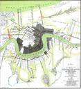
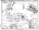
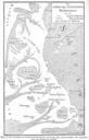
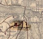
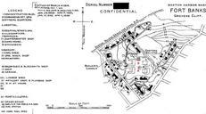
Banksmap. en map of Ft Banks shows the four mortar pits of Batteries Lincoln on the west and Kellogg on the east at the center of the map The two northerly pits see red labels each by contained two mortars while the southerly pits contained four mortars each Today only Kellogg Pit the northeastern pit is visible from the surface