
Related Images


Download:
| Tiny | 89x128 | View | Download |
| Small | 178x256 | View | Download |
| Medium | 357x512 | View | Download |
| Large | 714x1024 | View | Download |
| Original tiff | 4725x6772 | View | Download |
| Original as jpg | 4725x6772 | View | Download |
This image was acquired from
wikimedia. It was marked as Public Domain or CC0 and is free to use. To verify, go to the source and check the information there.
Looking for more info about this image?
Try a Google Reverse Image Search for it.
Try a Google Reverse Image Search for it.
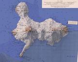
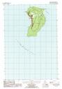
Keywords from Image Description:
High Island Michigan USGS Topo Map .tif InteractiveViewer en map of High Island Beaver Islands Lake Michigan Michigan USA topoquest php usgscellid USGS other versions PDUSGov Islands of Lake Michigan United States Geological Survey Topographic maps of Michigan maps