
Related Images


Download:
| Tiny | 171x128 | View | Download |
| Small | 343x256 | View | Download |
| Medium | 686x512 | View | Download |
| Large | 1372x1024 | View | Download |
| Original | 3828x2856 | View | Download |
This image was acquired from
wikimedia. It was marked as Public Domain or CC0 and is free to use. To verify, go to the source and check the information there.
Looking for more info about this image?
Try a Google Reverse Image Search for it.
Try a Google Reverse Image Search for it.
Keywords from Image Description:
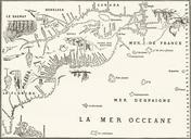
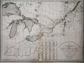
KENSETT MAP CANADA . en Rare separately issued map of the Great Lakes Michigan Indiana Ohio and contiguous parts of the Canada and the Northeast The map shows the primary area of conflict during the opening stages of the War of including many forts along the Canadian border except Fort York Includes Fort Washington Cincinnati Fort