
Related Images


Download:
| Tiny | 384x128 | View | Download |
| Small | 769x256 | View | Download |
| Medium | 1538x512 | View | Download |
| Large | 3076x1024 | View | Download |
| Original | 3245x1080 | View | Download |
This image was acquired from
wikimedia. It was marked as Public Domain or CC0 and is free to use. To verify, go to the source and check the information there.
Looking for more info about this image?
Try a Google Reverse Image Search for it.
Try a Google Reverse Image Search for it.
Keywords from Image Description:
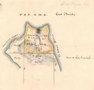
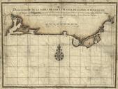
Map of part of East Florida from St. John's River to Bay of Mosquitos. en Map of part of East Florida from the St Johns River to the Bay of Mosquitos showing names of proprietors of estates Drawn from the original plan of John Gordon and given to Governor Grant by James Moncrief Engineer Early Maps of the American South Collections