
Related Images


Download:
| Tiny | 204x128 | View | Download |
| Small | 409x256 | View | Download |
| Medium | 819x512 | View | Download |
| Large | 1638x1024 | View | Download |
| Original | 5827x3642 | View | Download |
This image was acquired from
wikimedia. It was marked as Public Domain or CC0 and is free to use. To verify, go to the source and check the information there.
Looking for more info about this image?
Try a Google Reverse Image Search for it.
Try a Google Reverse Image Search for it.
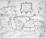
Keywords from Image Description:
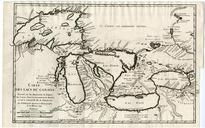
bellin map Carte des lacs du Canada. Carte des Lacs du Canada Dressee sur les Manuscrits du Depost des Cartes Plans et Journaux de la Marine et sur le Journal du RP De Charlevoix Par Bellin Ingenieur et Hdrographe de la Marine de Karte der Groen Seen Beinhaltet auch die Phantominseln Phlipeaux und Pontchartrain en Map of the Great