
Related Images
Download:
| Tiny | 102x128 | View | Download |
| Small | 204x256 | View | Download |
| Medium | 409x512 | View | Download |
| Large | 819x1024 | View | Download |
| Original | 4804x6000 | View | Download |
This image was acquired from
wikimedia. It was marked as Public Domain or CC0 and is free to use. To verify, go to the source and check the information there.
Looking for more info about this image?
Try a Google Reverse Image Search for it.
Try a Google Reverse Image Search for it.
Keywords from Image Description:
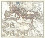
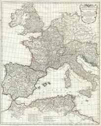
Anville Map of the Western Roman Empire including Italy Geographicus RomanEmpireWestanville. This is the stunning western sheet from Jean Baptiste Bourguignon Anville two map set depicting the Roman Empire Depicts the western portion of the Roman Empire from Italy and Dalmatia westward to include all of Spain Ireland and England