
Related Images

Download:
| Tiny | 102x128 | View | Download |
| Small | 204x256 | View | Download |
| Medium | 408x512 | View | Download |
| Large | 817x1024 | View | Download |
| Original | 3990x5000 | View | Download |
This image was acquired from
wikimedia. It was marked as Public Domain or CC0 and is free to use. To verify, go to the source and check the information there.
Looking for more info about this image?
Try a Google Reverse Image Search for it.
Try a Google Reverse Image Search for it.
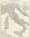
Keywords from Image Description:
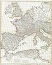
Anville Map of Itally in Roman Times Geographicus ItalyAntiquaeanville. large and dramatic D'Anville map of Italy in ancient Roman times Covers from Lake Geneva Lemanus Lac to Sicily Sicilia inclusive of the entire Italian peninsula Sardinia Corsica Sicily and Dalmatia Details mountains rivers cities roadways and lakes with political