
Related Images

Download:
| Tiny | 85x128 | View | Download |
| Small | 171x256 | View | Download |
| Medium | 342x512 | View | Download |
| Large | 685x1024 | View | Download |
| Original | 1673x2500 | View | Download |
This image was acquired from
wikimedia. It was marked as Public Domain or CC0 and is free to use. To verify, go to the source and check the information there.
Looking for more info about this image?
Try a Google Reverse Image Search for it.
Try a Google Reverse Image Search for it.
Keywords from Image Description:
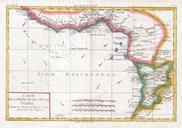
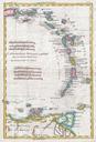
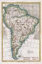
Raynal and Bonne Map of Peru Geographicus Peroubonne. fine example of Rigobert Bonne and Guillaume Raynal map of Peru Covers from the Pacific well into the Amazon and as far south as the Aconcagua Desert Shows Tradewinds in the pacific and shows mountains in profile number of important indigenous villages and mission stations