
Related Images
Download:
| Tiny | 119x128 | View | Download |
| Small | 239x256 | View | Download |
| Medium | 479x512 | View | Download |
| Large | 958x1024 | View | Download |
| Original | 4500x4806 | View | Download |
This image was acquired from
wikimedia. It was marked as Public Domain or CC0 and is free to use. To verify, go to the source and check the information there.
Looking for more info about this image?
Try a Google Reverse Image Search for it.
Try a Google Reverse Image Search for it.
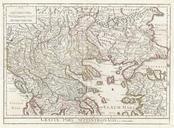
Keywords from Image Description:
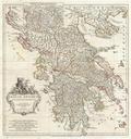
Anville Map of Ancient Greece Geographicus GreeceAncientanville. large and dramatic D'Anville map of Ancient Greece Covers from Macedonia to the Peloponnesus inclusive of Euboea and the Ionian Isles Details mountains rivers cities roadways and lakes with political divisions highlighted in outline color Decorative title cartouche