
Related Images

Download:
| Tiny | 107x128 | View | Download |
| Small | 215x256 | View | Download |
| Medium | 431x512 | View | Download |
| Large | 863x1024 | View | Download |
| Original | 2500x2963 | View | Download |
This image was acquired from
wikimedia. It was marked as Public Domain or CC0 and is free to use. To verify, go to the source and check the information there.
Looking for more info about this image?
Try a Google Reverse Image Search for it.
Try a Google Reverse Image Search for it.
Keywords from Image Description:
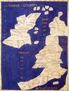
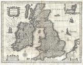
Spruneri Map of the British Isles Britannia Hibernia in Ancient Times Geographicus Britaniaspruneri. This fine hand colored map is steel plate lithograph depicting the British Isles in Ancient times Titled Britannia et Hibernia There are insets of Hadrian Wall and Britain as it was conceived by Ptolemy and Strabo It was published