
Related Images


Download:
| Tiny | 88x128 | View | Download |
| Small | 176x256 | View | Download |
| Medium | 353x512 | View | Download |
| Large | 706x1024 | View | Download |
| Original | 1724x2500 | View | Download |
This image was acquired from
wikimedia. It was marked as Public Domain or CC0 and is free to use. To verify, go to the source and check the information there.
Looking for more info about this image?
Try a Google Reverse Image Search for it.
Try a Google Reverse Image Search for it.
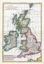
Keywords from Image Description:
Raynal and Bonne Map of British Isles Geographicus IslesBritanniquesbonne. fine example of Rigobert Bonne and Guillaume Raynal map of the British Isles Covers Ireland Scotland Wales England Isle of Man and the Channel Islands Highly detailed showing towns rivers some topographical features important roadways and political boundaries