
Related Images


Download:
| Tiny | 159x128 | View | Download |
| Small | 319x256 | View | Download |
| Medium | 638x512 | View | Download |
| Large | 1276x1024 | View | Download |
| Original | 2500x2005 | View | Download |
This image was acquired from
wikimedia. It was marked as Public Domain or CC0 and is free to use. To verify, go to the source and check the information there.
Looking for more info about this image?
Try a Google Reverse Image Search for it.
Try a Google Reverse Image Search for it.
Keywords from Image Description:
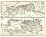
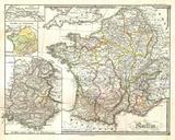
Spruneri Map of France Gaul Gallia in Ancient Times Geographicus Galliaspruneri. This fine hand colored map is steel plate lithograph depicting France Gaul or Gallia in ancient times There are large insets of Batavorum and France after Caesar It was published in by the legendary German cartographer Justus Perthes Issued as