
Related Images


Download:
| Tiny | 157x128 | View | Download |
| Small | 315x256 | View | Download |
| Medium | 630x512 | View | Download |
| Large | 1261x1024 | View | Download |
| Original | 4000x3247 | View | Download |
This image was acquired from
wikimedia. It was marked as Public Domain or CC0 and is free to use. To verify, go to the source and check the information there.
Looking for more info about this image?
Try a Google Reverse Image Search for it.
Try a Google Reverse Image Search for it.
Keywords from Image Description:
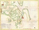
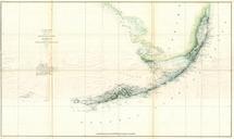
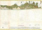
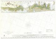
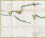
U.S.C.S. Map or Chart of Penascola Bay and Harbor Florida Geographicus Pensacolauscs. This is rare hand colored Coast Survey nautical chart of the Entrance to Pensacola Bay Florida Covers Pensacola Bay from The Lagoon eastward past Warrington and Woolsey to Pensacola Depicts the Islands of Santa Rosa and Fort Pickens as well


